The purpose of this study is to understand what is the current situation in Essex about Ultra Low Emission Vehicle (ULEV). The British government defines ULEV as vehicle that emits less than 75 CO2g/km (ULEV definition), it mainly correspond to Battery Electric Vehicle (BEV) and Plug-in Hybrid Electric Vehicle (PHEV). The number of ULEV has dramatically increased in the last decades pushed by the need to reduce the road emissions. This study is focused on analysing the data related to ULEV in Essex, including the geospatial onformation, and charging infrastructure. The data are coming from the government website: gov.uk. The data used are up-to-date as of 2020 Q3 and split by postcode area (73 areas). The analysis and visualisation are done with python using the libraries "bokeh" and "folium" for the visualisation.
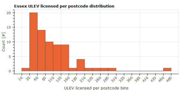
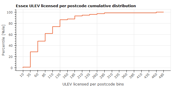
In 2020 Q3, there was 7840 ULEVs in Essex, inequally split across the postcode areas. The postcode area CO8 (Braintree, Colchester) has only 13 ULEVs licensed while the postcode area SS15 (Basildon) has 471 ULEVs licensed. There is an average of 107 ULEVs licensed per postcode area.
 |
 |
Map 1: ULEVs in Essex 2020 Q3
- Some postcodes are shared across multiple places/councils, that is why some "Councils" fields have multiple names.
- The majority of postcode areas have between 35 and 160 ULEVs registered.
- In SS15 there is a peak number of ULEV, 471 vehicles, that could be seen on the distribution graph. It might be due to the presence of a Ford technical
centre (Ford Dunton) in this area and supported by the following comment that could be found in the raw data: "Vehicles are allocated to a local
authority according to the postcode of the registered keeper. This is the keeper's address for privately owned vehicles or the company's registered
address for company owned vehicles. The address does not necessarily reflect where the vehicle is located. This is especially true for large fleets kept
by companies involved with vehicle management, leasing or rentals. Significant changes in the number of vehicles from year to year can often occur when
these companies change their registered address."
- The postcode area SG8 (North West) is spread across multiple counties and only a small part of it is in Essex. So the number of 285 ULEVs is misleading
as it represents the whole number of ULEV in all the postcode area not only the Essex part.
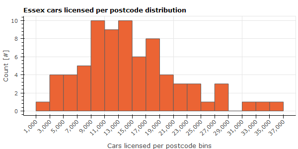
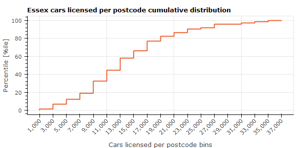
The number of ULEV alone does not allow to give enough information about the current situation of ULEV. It must be compared with the total amount of cars regardless of the type. In 2020 Q3, there was 1,093,513 cars licensed. The postcode area CO8 (Braintree, Colchester) has only 1,578 cars licenced while the postcode area CM3 (Braintree, Chelmsford, Maldon, Uttlesford) has only 35,076 cars licensed.
 |
 |
Map 2: cars in Essex 2020 Q3
- The cars licensed are more evenly distributed than ULEVs between the postcode areas.
- The highest number of cars licensed are in the centre of Essex around Chelmsford.
- The bigger the postcode area the higher the chance to have a big amount of cars licensed.
The ratio of ULEV per cars is calculated, there is from 0.22 to 1.99 of ULEV per 100 cars.
Map 3: ratio ULEVs/100cars in Essex 2020 Q3
- The West part of Essex is globally the part with the highest number of ULEV per cars.
- SS15 is the postcode area with the highest ratio of ULEV per cars with almost 2% of ULEV.
- Some postcodes, like CO14, either do not have ULEV or no data are available.
The charging points data are added to understand whether access to charging is enough based on the number of ULEV. There is a total of 108 charging points, which compare to 7840 ULEV is very low (a bit more than 1 charging point for 100 ULEVs).
 |
 |
Map 4: charging points in Essex
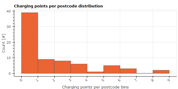
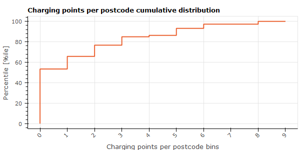
- More than 50% of the postcode areas do not have charging points.
- 2 postcode areas (CM4, CO2) have 9 charging points each which is the highest number.
Map 5: charging points/ULEV in Essex
- The postcode area RM20 (Thurrock) has the highest number of charging points per 100 ULEVs (16 charging points per 100 ULEVs).
Map 6: charging points locations in Essex